Spatial planning
A new spatial vision
for Central Europe through
cross-border planning
Interested in cross-border spatial planning?
Join the BorderLabs CE community to plan beyond borders together!

Between 1994 and 1999, the European Union’s first integrated territorial vision, the ESDP, was created. The document summarised the various national development needs in an exemplary way, preparing the EU for the accession of the new Member States and also introducing European spatial planning. Although a single European territorial policy has not been established since then and Member States have not applied the ESDP territorial vision with the same enthusiasm and the same commitment, the document has still had a number of pan-European impacts: the development and consolidation of transnational Interreg programmes, the launch of the ESPON programme, the integration of territorial aspect into cohesion policy, the spread of polycentric urban development practices, the introduction of territorial impact analysis in the policy-making process, etc. can all be seen as a result of the ESDP.
The vision for the Central European region, Vision Planet, was also inspired by the document and led to the launch of the CADSES programme, which then split into the Danube and Central Europe programmes and partly merged into the Adriatic-Ionian programme. In the meantime, in addition to funding frameworks, new development policy initiatives have emerged. Currently, the Central European region is divided into four macro-regions, which have different intervention logics and development priorities, and their interventions are mostly not coordinated. In the meantime, a new macro-regional cooperation covering the Carpathians is also being developed. These will further reinforce the fragmentation of the region, although the Member States located in the former CADSES region will play a crucial integrating role in the planned enlargement process. Their geographical location, their security and geopolitical role, the location of the existing infrastructure elements, their direct economic and social relations with the acceding countries, the existence of cross-border forms of governance and their experience in the previous enlargement process precede this.
Seamless integration presupposes the creation of a comprehensive territorial vision at European level, to which macro-regional, bi- or multilateral, national, regional and cross-border planning processes can adhere. To achieve this aim, the vision-building processes at each territorial level will have to be coordinated.
The establishment of CEMAT in 1970 marked the institutional genesis of European spatial policy, providing the first high-level political forum to address spatial development beyond isolated national frameworks.
From a cross-border planning perspective, this early initiative was pivotal in beginning to challenge the traditional “container logic” of spatial understanding, where border areas were merely treated as the edges of separate national containers with entirely distinct developmental goals and governmental competencies.
By laying the groundwork for spatial observation and trans-European dialogue, CEMAT planted the seeds for a bottom-up approach to regional territorial cohesion and the future conceptualisation of cross-border spaces as coherent unities and independent planning entities.
Furthermore, functioning under the auspices of the Council of Europe, it conceptually paved the way for subsequent legal instruments, which later became essential for establishing integrated spatial development.
The Torremolinos Charter, adopted by the Council of Europe in 1983, is a foundational document that laid the conceptual groundwork for territorial cohesion on a continental scale.
To mitigate the separating effects of borders, the Charter established the theoretical framework for treating cross-border areas as coherent unities and independent planning entities capable of jointly exploiting their shared “territorial capital”.
The document shifted towards a more modern, relational spatial perspective, recognising that border regions are not isolated, marginal peripheries, but rather complex contact zones and networks that require a joint, integrated strategic approach.
Although the international public law frameworks of the time, along with top-down mechanisms emphasising strict state sovereignty, still hindered the full institutionalisation of such cooperation, the document's guidance created an indispensable intellectual foundation for the subsequent dismantling of administrative obstacles and the future emergence of multi-level cross-border governance by territorial authorities.
After facing financial difficulties, CEMAT reduced its activities in the late 1980s. As a consequence, the Dutch and French ministers responsible for territorial development initiated a new impetus beyond the Council of Europe.
The 1989 informal ministerial meeting in Nantes, held in the presence of the head of the Commission, Jacques Delors, marked a milestone in European spatial policy by initiating the gradual transfer of CEMAT's tasks and objectives into the framework of the European Economic Community.
This strategic shift steered the previously loose intergovernmental territorial dialogue towards tighter EU integration, laying the political foundations for Community-level tools in cross-border planning and the future European spatial development policy.
The 1996 publication of the First Cohesion Report was the first, though embryonic, assessment of economic and social disparities across the Member States.
Although the formal principle of territorial cohesion would only explicitly complement the goals of economic and social convergence in the following decade, this inaugural report exposed the existing deep regional imbalances throughout the EU.
By highlighting the persistent marginalisation of peripheral borderlands, it underscored the urgent need for joint spatial strategies and systematic cross-border planning to bridge these developmental gaps. Ultimately, the report laid the analytical foundation for subsequent European spatial frameworks.
The 1999 publication of the European Spatial Development Perspective (ESDP) marked a paradigm shift in European regional policy by introducing the first comprehensive, integrated strategic framework for EU-wide territorial cohesion.
The ESDP was completely unprecedented because it served as the very first strategic document to coordinate spatial development visions on a European scale, establishing a pioneering framework for how integrated cross-border planning should be conducted to overcome traditional national logic and treat border areas as coherent, shared functional spaces.
Its profound novelty lay in moving beyond isolated sectoral approaches to advocate for polycentric spatial development, the expansion of integrated transport and communication infrastructure, and the intelligent management of natural and cultural heritage.
For several countries in the Central European region, which were preparing for EU accession, the ESDP served as a crucial strategic compass. It provided the conceptual and methodological foundation for transnational cooperation programmes and the joint exploitation of cross-border territorial capital across newly opening, historically fragmented frontiers.
Furthermore, its institutional legacy, such as the eventual launch of the ESPON programme in 2002, provided the essential harmonised territorial data and observation tools needed to support evidence-based, integrated spatial planning across Central Europe.
Published in 2000, the Vision Planet document represented a pioneering transnational spatial planning initiative tailored specifically for the Central European, Adriatic, Danubian, and South-Eastern European (CADSES) macro-region.
From a cross-border planning perspective, this strategic framework was instrumental in translating pan-European spatial objectives into a highly fragmented geographical context of the CADSES region.
By emphasising the need to view these newly opening borderlands as coherent functional spaces rather than peripheral margins, the document advocated for the joint and sustainable exploitation of the region’s shared territorial capital.
Ultimately, Vision Planet laid the critical methodological and conceptual groundwork for subsequent transnational INTERREG programmes across the Danubian, Central European and Adriatic areas, highlighting that achieving true territorial cohesion requires joint spatial strategies to heal historical ruptures and weaken the separating effects of borders across Central and Eastern Europe.
The Second Cohesion Report by the European Commission formally elevated the concept of “territorial cohesion” to complement the traditional pillars of economic and social cohesion.
The emergence of this principle introduced a radically new approach to spatial development: moving beyond the mere economic catch-up of lagging areas towards the sustainable, integrated, and shared exploitation of a region’s territorial capital.
The launch of the ESPON programme in 2002 emerged as a direct institutional consequence of the European Spatial Development Perspective (ESDP).
By establishing a continent-wide network for spatial observation and analysis, ESPON addressed one of the most significant barriers to integrated development: the lack of comparable, reliable, and harmonised territorial data and evidence across different national statistical systems.
From a cross-border planning perspective, the programme has been providing crucial methodological support and advanced analytical instruments, such as the ESPON Territorial Impact Assessment (TIA), to accurately measure and valorise the shared territorial capital of divided border areas, among others.
Published on the eve of the 2004 enlargement, the Third Cohesion Report formally proposed elevating territorial cohesion alongside economic and social cohesion to address expanding spatial disparities across the reunited continent.
By recommending the creation of a standalone European Territorial Cooperation objective, it laid the structural foundation for integrated cross-border planning and permanent governance to dismantle the separating effects of national borders.
Presented at the Informal Ministerial Meeting on Regional Policy and Territorial Cohesion in Luxembourg, the document The Territorial State and Perspectives of the European Union: Towards a stronger European territorial cohesion in the light of the Lisbon and Gothenburg ambitions (abbreviated as TSP) marked a major conceptual evolution in European cross-border governance and spatial development policy.
Building upon the 1999 European Spatial Development Perspective and leveraging empirical analyses from ESPON, this scoping paper provided the direct evidence-based foundation for the subsequent Territorial Agenda of the European Union (2007).
The document fundamentally redefined cohesion policy by shifting the focus from purely compensatory financial transfers toward mobilising each region’s inherent “territorial capital” — its unique geographical, institutional, cultural, and social assets.
It established that territorial cohesion requires tailor-made, place-based development strategies rather than one-size-fits-all national policies.
It formally integrated spatial planning into the core EU political agenda, demonstrating that European economic competitiveness and environmental sustainability could only be achieved by explicitly considering their spatial dimensions, such as polycentric urban networks, urban-rural partnerships, and functional cross-border integration.
The report also diagnosed the lack of a formal EU-level territorial governance framework capable of reconciling conflicting sectoral policies with local spatial development needs and promoted evidence-based spatial policy-making using ESPON territorial data and mapping.
Furthermore, the document elevated borderlands from forgotten outer peripheries into coherent functional territories, legitimising joint cross-border spatial development strategies, cross-border polycentric urban networks, and coordinated territorial frameworks.
The year 2007 represented a watershed moment for European spatial policy, driven by the publication of the Fourth Cohesion Report and the adoption of the Lisbon Treaty, canonising the territorial aspect of cohesion, the Leipzig Charter laying the ground for a new urban policy, alongside the Territorial Agenda and its corresponding Action Programme.
These milestone documents collectively championed a place-based, integrated strategic approach, emphasising that an optimal balance between ecological sustainability, economic competitiveness, and social cohesion can only be achieved through the integrated development of territories.
For cross-border planning, the 2007 cohesion policy framework officially launched the European Territorial Cooperation objective as an independent, standalone priority, shifting away from temporary community initiatives to mandate truly joint programming and shared ownership of regional strategies.
By recognising border regions as spaces with unique developmental challenges and complementary assets, this renewed framework demanded the holistic exploitation of territorial capital through participatory methods rather than isolated, superficial local interventions.
The Network of Territorial Cohesion Contact Points supported intergovernmental dialogue and the monitoring of spatial trends across Europe. These strategic developments also coincided with the practical application of the EGTC Regulation in August 2007, providing local and regional authorities with a legal instrument for integrated investment and permanent cross-border governance.
Treaty of Lisbon ↗
Fourth Cohesion Report ↗
Leipzig Charter on Sustainable European Cities ↗
Territorial Agenda 2007 ↗
First Action Programme of the Territorial Agenda ↗
The Green Paper on Territorial Cohesion is considered one of the most important documents in this field, explicitly emphasising the necessity of problem-solving approaches and interventions that integrate various economic sectors to achieve genuine territorial cohesion.
For cross-border planning, the Green Paper reinforced the idea that territorial cohesion necessitates a bottom-up approach, establishing that true integration is created at the local and regional levels rather than merely being managed from the EU level.
This shift in perspective highlighted that border areas possess unique territorial capital that requires complex, multi-faceted planning strategies rather than isolated, superficial local projects.
By promoting territorially integrated investments over purely sectoral approaches, the document laid the essential groundwork for cohesion-based cross-border development and further validated the necessity of permanent, multi-level governance structures to oversee shared regional strategies.
The 2009 publication of the independent Barca Report, An Agenda for a Reformed Cohesion Policy, brought a paradigm shift by rigorously advocating for a “place-based” approach in European regional development.
For cross-border planning, this comprehensive assessment echoed the growing recognition that both local stakeholders and European institutions urgently require a more place-based methodology in planning, development, governance, and legal harmonisation.
By prioritising the unique, endogenous resources of specific areas over space-blind sectoral policies, the report underscored that the complex challenges of borderlands cannot be solved through superficial, unsustainable interventions.
Instead, it validated a bottom-up strategy where territorial cohesion is actively created at the local and regional levels, relying on shared narratives and the joint exploitation of the border area’s territorial capital.
Furthermore, the Barca Report reinforced the critical need for robust cross-border multi-level governance structures such as the EGTC to effectively implement these integrated strategies, ensuring that the positive effects of European integration and territorial cooperation become more visible and tangible for citizens.
The Fifth Cohesion Report, published in 2010, marked a critical evolution by formally linking the goals of territorial cohesion to the ambitious targets of the Europe 2020 strategy for smart, sustainable, and inclusive growth.
In the context of cross-border planning, it shifted the focus from merely reducing disparities to actively demanding a more results-oriented, place-based programming approach, setting the stage for tools like Integrated Territorial Investments (ITI) to implement highly complex, multi-sectoral strategies across borders.
The adoption of the Territorial Agenda 2020 (TA2020) in 2011 established the integrated strategic approach as the central guiding principle for future European spatial policy.
The document explicitly emphasised that the optimal balance between sustainability, competitiveness, and social cohesion can only be achieved through the integrated development of territories.
From a cross-border planning perspective, the ministers who adopted the document strongly supported the necessity of territorially integrated approaches to address complex local and regional challenges.
By closely aligning its principles with the upcoming EU cohesion policy regulations, TA2020 solidified the shift towards multi-sectoral mechanisms like Integrated Territorial Investments (ITI), ensuring that future cross-border strategies provide comprehensive, place-based solutions rather than isolated, fragmented interventions.
Launched to operationalise the political objectives of the European spatial agenda, the ESPON INTERCO project marked a crucial step in making territorial cohesion empirically measurable.
Building upon the analytical foundation of the broader ESPON programme, the project developed a comprehensive set of indicators to monitor spatial integration and disparities across European regions.
From a cross-border planning perspective, INTERCO was instrumental in providing policymakers with the tangible, quantifiable data needed to evaluate the true functional interconnectedness of borderlands.
By translating the abstract concept of territorial cohesion into measurable metrics, it enabled local and regional authorities to better assess their shared territorial capital and design more targeted, evidence-based joint strategies.
The Sixth Cohesion Report (2014) evaluated the impact of the economic crisis on European regions while consolidating the 2014–2020 legislative framework around results-driven, place-based investments.
For cross-border planning, it highlighted practical delivery instruments like Integrated Territorial Investments (ITI) to empower local governance and optimise the shared territorial capital of borderlands.
Published in 2017, the Seventh Cohesion Report highlighted uneven regional recovery following the economic crisis, laying the strategic foundation for the post-2020 cohesion policy framework centred on innovation, decarbonisation, and administrative capacity.
From a cross-border planning perspective, it emphasised that unlocking the full potential of borderlands requires moving beyond traditional infrastructure investments toward actively dismantling remaining legal and administrative barriers through enhanced multi-level governance.
The adoption of the Territorial Agenda 2030 (TA2030) marked a decisive shift from a purely strategic, visionary document towards a highly action-oriented framework for European spatial policy.
Compared to its predecessor TA2020, its most significant novelty was the introduction of concrete Pilot Actions designed to test and implement territorial priorities practically across various governance levels, moving spatial planning from theoretical consensus to tangible delivery.
Furthermore, TA2030 fundamentally restructured its overarching vision into two clear pillars, a “Just Europe” and a “Green Europe”, explicitly aligning European territorial cohesion with broader global frameworks such as the UN Sustainable Development Goals and the European Green Deal.
From a cross-border planning perspective, the new Agenda brought a renewed emphasis on “functional areas” as living labs for territoriality, urging policymakers to look past rigid administrative borders when managing shared public amenities, water resources, or transit systems.
By stressing that demographic decline, climate change, and spatial inequalities affect territories differently, TA2030 championed deeply customised, place-based responses, cementing cross-border cooperation not just as a financial objective, but as an absolute necessity for ensuring a desirable future for all places and people.
Adopted during the German EU Presidency in 2020, the New Leipzig Charter provides the updated strategic European framework for sustainable urban development.
The document focuses on the transformative power of cities, advocating for integrated urban policies that promote the common good by building “just”, “green”, and “productive” urban environments.
It strongly emphasises a place-based approach and the necessity of multi-level governance to empower local authorities in tackling contemporary societal, environmental, and economic crises.
From the specific perspective of cross-border spatial planning and development, the Charter’s most significant novelty is its decisive shift from rigid administrative borders toward the concept of the “functional area” incorporating a distinct zone around the given urban centres apart from the core settlement.
It explicitly recognises that daily urban realities such as commuter flows, economic supply chains, and environmental challenges frequently transcend municipal as well as national borders.
By strongly advocating for policy alignment and joint strategies within functional urban areas, including cross-border agglomerations and twin cities, the Charter provides a critical policy justification for border municipalities to move beyond isolated national planning.
Implemented between 2020 and 2022, the Pilot Action on Cross-Border Spatial Planning directly operationalised the action-oriented vision of the newly adopted Territorial Agenda 2030.
By bringing together national, regional, and local stakeholders across functional border territories, this initiative moved beyond high-level policy dialogue to test practical, place-based methodologies for joint spatial development in and around Luxembourg.
From a cross-border planning perspective, the pilot action specifically tackled the harmonisation of differing national planning cultures and legal frameworks, demonstrating how multi-level governance can actively resolve persistent legal and administrative bottlenecks.
Ultimately, the project served as a tangible proof-of-concept for TA2030’s “Just Europe” and “Green Europe” priorities, showcasing how functional area planning can practically enhance public service provision, green infrastructure, and overall territorial cohesion across European borders.
Published under the title Cohesion in Europe towards 2050, the Eighth Cohesion Report provided a comprehensive assessment of post-pandemic recovery while warning against the risk of lagging regions falling into persistent development traps driven by demographic decline, brain drain, and stagnant innovation.
It positioned the twin green and digital transitions as the main structural catalysts for future European regional policy.
From a cross-border planning perspective, the report reinforced that achieving climate neutrality and digital connectivity cannot be accomplished within isolated national boundaries, demanding stronger functional integration across border regions.
Ultimately, it highlighted that empowering local administrative capacity and developing joint cross-border services and green infrastructure are vital to keeping peripheral borderlands competitive, resilient, and socially cohesive up to 2050.
Published 20 years after the 2004 enlargement, the Ninth Cohesion Report (2024) demonstrates significant overall economic convergence across Member States while warning against persistent sub-national innovation divides, demographic contraction, and regions caught in regional development traps.
In terms of cross-border planning, it lays the groundwork for a simplified and performance-oriented post-2027 cohesion framework, positioning Interreg and macro-regional strategies as vital instruments to deliver shared public goods across borders and prepare candidate nations for future EU enlargement.
Implemented between 2024 and 2026, this pilot action represents another key operational milestone under the action-oriented commitments of the Territorial Agenda 2030, focusing on the systematic assessment of the territorial impacts of sectoral policies and legislation.
The initiative aims to provide a robust methodological framework for ex-ante and ex-post evaluations of the territorial dimensions of EU and national legislation, thereby preventing disproportionate negative impacts on different types of territories.
From a cross-border planning perspective, this pilot action directly addresses one of the primary challenges faced by border regions: persistent legal and administrative obstacles.
By refining and testing the toolkit for Regulatory Territorial Impact Assessment (TIA), the project enables a precise evaluation of how diverging national regulations and EU directives affect the daily functioning of cross-border functional areas.
This approach reinforces place-based decision-making, ensuring that regulatory frameworks do not hinder but actively facilitate the delivery of shared cross-border public services, infrastructure, and integrated development strategies.
Despite European planning efforts, it is still rare that the territorial development plans of a given country take into account the realities created by the intentions and policies of neighbouring countries. It is rather the practice that transboundary areas form a white spot, which sometimes severely affects the population of border regions. Often the territorial pattern of functions follows the domestic administrative system and urban network characteristics, creating a kind of gravity from the periphery to the centres. Public services are increasingly costly to maintain in depopulated border regions, and inefficiencies are driving decisionmakers to reduce them. This leads to further outmigration, and create territorial discontinuities along administrative boundaries.
In many cases, however, urban centres on the other side of the border could reduce the negative effects of depopulation, provided that their service functions are taken into account in national documents. This can not only increase the population-retaining power of disadvantaged areas, but also guarantee the economies of scale needed to operate the functions available across the border, creating a win-win situation for the budgets of both countries.
At macro-regional level, such service integration works against discontinuities, strengthens the volume of cross-border factor flows and territorial integration, while also increasing cohesion at regional level. In many parts of Central Europe, sharing services is still an exception, as the Cross-Border Public Services 2.0 project implemented within the framework of the ESPON programme pointed out spectacularly on the map.
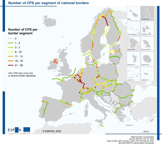
Source: ESPON CPS 2.0
At the same time, during the last decade more and more intensive relocation processes could be observed in some urban functional districts (e.g. Szczecin, Görlitz, Vienna, Bratislava, Košice, Oradea, etc.). In these cases, cross-border residential mobility generates development needs that are not taken into account in planning documents at national level for the same reason as in the case of the management of their own peripheries: suburbanisation processes around a cross-border centre cannot be predicted by a plan which does not indicate the centre due to the above-mentioned national competences for territorial development, as it is located beyond the border. At the Central European level, such cross-border functional areas (defined not only by cities but also by river valleys, nature reserves, industrial zones, educational institutions, etc.) can also be drivers of wider integration, coordination of territorial processes and balanced development of the whole region.
At the same time, the desired cross-border integrated planning is hampered by a number of factors. National statistical offices do not collect data on flows that determine cross-border integration: the number of commuters for work and educational purposes, users of public services, regular cross-border shoppers, movers, etc. is unknown. As a result of the abolition of internal border controls, there is no longer traffic counting at the border crossings.
The different planning traditions have also developed organically on a national basis, and the different zoning classifications, the related legal background and the different territorial administrative competence systems make it extremely difficult to coordinate the relevant settlement and development documents. And even if initiatives are taken by local actors to address these shortcomings, their funding is difficult to solve, limited to the duration of a project. Additionally, the relevant competences are usually not where the intention is.
A particular type of cross-border area is represented by the junctions of three national borders (so-called tripoints), where multiple administrative, legal, spatial, transport and logistical barriers converge. Tripoints provide valuable laboratories for cross-border cooperation and serve as testing grounds for innovative models of multi-level governance. A notable example is the Polish–Czech–German border region, which constitutes the biggest Pilot Action of the BorderLabs CE project.
However, good examples still exist today. CentropaMAP is the only initiative within the CADSES region that regularly collects and publishes data and maps on the phenomena of cross-border integration of the metropolitan region around Vienna (AT). The twin towns of Komárno (SK) and Komárom (HU) as well as Giurgiu (RO) and Ruse (BG) prepared their joint urban management plan in 2012. Within the Italy-Austria Interreg CBC Programme, four cross-border CLLDs (Community-led Local Development) are implemented, preceded by a participatory planning process.
Well-established examples from Western Europe demonstrate the long-term benefits of multilateral territorial governance. The Upper Rhine Region around Basel (France–Germany–Switzerland) and the Meuse–Rhine Euroregion (Belgium–Germany–Netherlands) show how cross-border functional areas can evolve into stable frameworks for spatial planning and territorial development, strategic planning, mobility management, innovation policies, and public service provision. In particular, these experiences demonstrate that the coordination of spatial policies across national borders contributes to more sustainable land use, more efficient infrastructure development, and the reduction of land-use conflicts.
At the same time, these examples and initiatives are isolated and not widely known. Cohesion in Central Europe and the integration of the new accession countries would be greatly facilitated if these examples would be treated as models in other regions, making cross-border planning a common practice within the CADSES region.
Cross-border planning has a dual aim: (1) to recover the disadvantaged situation of (border) areas left behind, and the discontent of people living there; (2) to diminish the barrier effects of the administrative borders. To achieve these goals, the first step for stakeholders is to identify the joint challenges and complementary advantages on which the joint vision can be built. The vision sets the stage for strategic documents that go beyond national frameworks and strengthen cross-border cohesion.
Cross-border planning cannot be separated from cross-border governance. First, the realisation of the plans and the sustainability of joint developments require a permanent form of governance. Second, the shared vision has to be given legitimacy through participatory planning methods, involving the civil society. Finally, the implementation of cross-border soft plans is impossible without matching them into hard planning documents, and the active involvement of the national, regional and local authorities. At the same time, the joint vision has to reach beyond the national confines.
The partners of the BorderLabs CE project have experience in the field of cross-border planning, whose lessons can be upscaled through a larger network of experts:
How can neighbouring regions plan their shared future when their planning systems stop at the border?
Cross-border territories are often functionally interconnected, but spatial planning remains largely organised within national and regional systems. Different planning frameworks, procedures, competences and levels of decision-making can make it difficult to develop a shared understanding of territorial needs and priorities.
This challenge becomes particularly important when regions face common pressures such as economic transformation, demographic change, mobility needs, environmental challenges or the development of shared infrastructure. Addressing these issues requires a perspective that goes beyond individual administrative territories.
The experience explored a coordinated and cross-border approach to spatial planning, bringing together different planning traditions, expert knowledge and territorial perspectives. Rather than seeking to harmonise national planning systems, the approach focuses on creating a shared strategic vision that can provide a common direction while remaining compatible with each country’s own planning instruments and legal framework.
Discover how cross-border planning drives real regional development through these 5 quick Shorts from BorderLabs CE. You’ll get an inside look at strategic planning, joint decision-making, and tackling shared challenges in the Three-Country Border Area, while exploring how the EGTC GO in Gorizia operates as an action-driven “cross-border laboratory” for real-world solutions.
Complete the quiz to put your knowledge into practice!

Copy the suggested text below and paste it into your LinkedIn or Facebook post.
Copy the details below and paste them into the LinkedIn certification form.
Share your opinion on cross-border spatial planning in Central Europe. Your response is anonymous and will be collected only for aggregated analysis.
This platform has been developed within the BorderLabs CE project, supported by the Interreg CENTRAL EUROPE Programme with co-financing from the European Union. Its content, including any analyses, interpretations, opinions, forecasts and recommendations, is the sole responsibility of the authors and the project partnership and does not necessarily reflect the views or positions of the Interreg CENTRAL EUROPE Programme, its programme bodies or the European Union.
This platform has been developed within the BorderLabs CE project, supported by the Interreg CENTRAL EUROPE Programme with co-financing from the European Union. Its content, including any analyses, interpretations, opinions, forecasts and recommendations, is the sole responsibility of the authors and the project partnership and does not necessarily reflect the views or positions of the Interreg CENTRAL EUROPE Programme, its programme bodies or the European Union.